Early this morning National Geographic Sea Lion began a slow passage into the province of British Columbia, Canada. We were headed for the port city of Prince Rupert, located on Kaien Island near the Alaskan Panhandle. This port city is the land, air, and water transportation hub of British Columbia’s north coast.
Prince Rupert’s sheltered harbor is the deepest ice-free in North America, and the third deepest natural harbor in the world. The city is situated at 54 degrees north and also is the first inbound and last outbound port of call for many cargo ships traveling between eastern Asia and western North America.
The years from 1996 to 2004 were difficult ones for Prince Rupert. The closure of a large local pulp mill and the burning down of a fish plant all added to a significant population decline. The year 2005 may be viewed as a critical turning point with the announcement of the construction of a container port, combined with an influx of new ownerships in local pulp mills and most critical, the opening of a new container port in April of 2005. In addition, a new cruise ship dock was built and the resurgence of coal and grain shipping to Prince Rupert for shipping out into the world. The prospects of increased heavy industry and tourism may foretell a much brighter future for the area of and around Prince Rupert.
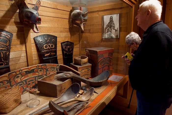
The museum is built according to a long standing Haida style longhouse, based around four large corner poles, the front poles are called gaats (uncarved support poles). Across the tops of these, from the front to the back of the house, tsan skagat (support poles). Supportive cross beams run horizontally on top of these. Large spilt cedar shakes are then placed on the roof and secured with large stones. Finally, spilt cedar planks are slotted into sills along the sides of the house, creating walls and Naay elilaas, a wide and tall cedar chimney top or large smoke hole funnels all the smoke from the central fire located on the floor of the dwelling, outside.
This lock and key construction was used throughout the museum complex and as we wandered from exhibit to exhibit we were surrounded by the smell of cedar and the visual of cedar posts and poles in and around and over-head! Each room was filled with extraordinary displays and explanations of the First Nations of the northern part of British Columbia. Regalia from earlier times was mixed with modern pieces created by current artists of the area. After a comfortable wander through many of the galleries, many of us took an opportunity to explore Prince Rupert…admiring the mural art on many buildings, exploring small parks and watching the comings and goings of this natural harbor and important port city.
All aboard time was set for 3:30 p.m., and National Geographic Sea Lion made her way south past Holland Rock shortly after, maneuvering left at Lawyer Island, then southeast through protected waters into Ogden Channel, then further south through Beaver Passage and one last westward turn through Browning Entrance and across Hecate Strait, approximately 50 miles from land point to land point…ultimately to bring our ship into the archipelago of Haida Gwaii early tomorrow morning.