
Call +1.800.397.3348 or contact your travel advisor
Expedition Stories
Our fleet navigates the world in search of adventure. These are the stories they bring back…
Loading...
Loading...
Previous Reports
7/12/2013
Read
National Geographic Explorer
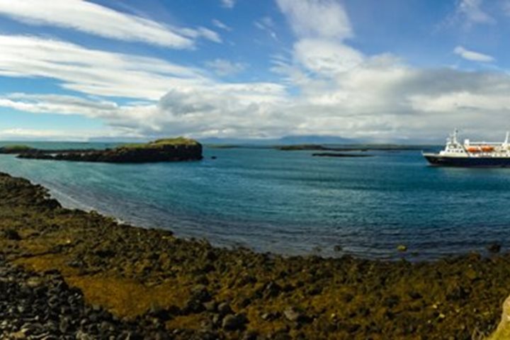
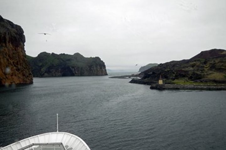
Latrabjarg and Flatey, Iceland
Yesterday we had our first taste of the Icelandic landscape on a tour of the hinterland from Reykjavik. We travelled north to the spectacular tear in the island’s surface at Thingvellir, site of the ancient Viking parliament, had lunch in Geysir where the steam geyser Strokkur blows its top every 3-4 minutes, then visited two breathtaking waterfalls at Gulafoss and Flaxi. We completed our circuit via the crumpled black and green volcanic wasteland of the Blue Mountains, arriving with perfect timing at the docks an hour before National Geographic Explorer cast off for our circumnavigation of Iceland. After sailing north through the night on an unruffled ocean, we woke to a grim prospect: huge black cliffs with their heads in the clouds, and rain showers blowing through from the west. But patience was rewarded: careful watching revealed an ocean full of wildlife: a minke whale across our bow, fulmars tearing at a lion’s-mane jellyfish, and everywhere shoals of small fish puckering the water up ahead. This dramatic headland is Latrabjarg, 40 miles of basalt precipice, a layer cake of lava flows which provides ideal nesting shelves for thousands of seabirds. As the Gulf Stream collides with this headland it stirs up the perfect plankton broth to feed the multitude: everywhere we looked there were guillemots, razorbills, fulmars, kittiwakes and our favorite auk, tiny sea-parrot, the puffin. As we watched, the clouds raised their hats, the rain moved east and soon the sun was sparkling on the waters, revealing the chestnut bands between each layer of black basalt in the cliffs, green daubs of vegetation on the crags and high up, the whirring clouds of seabirds, like bees swarming at a hive. The ship turned and headed deeper into the huge inlet of Breidafjordur, 30 miles wide by 70 long. Our afternoon destination was the tiny island of Flatey, a flat green pancake of land barely a mile long, but which in its day was one of the busiest trading sites in the whole of Iceland. Occupied since the first Viking adventurers settled to farm and fish, it was close to the best fishing grounds of the west coast and by the 16 th century, one of the most lucrative trading outposts of the Hanseatic League, whose commercial tentacles sought salted cod and paid good money to the hardworking fishermen of the day. It is a quiet, tranquil place now but typical of the tight-knit communities which became the backbone of a modern Norse nation. We walked, enchanted, over the lush grasslands, amid piping redshanks and drumming snipe, to the bright wooden houses of the summer community. Locals were knitting on their doorsteps or cooking for the day visitors, happy under a blue sky full of swirling marestails. As a final treat, we cruised by Zodiac past trusting puffins and tiny feeding phalaropes, under the nests of dainty kittiwakes on the basalt cliffs, and so back to the ship where the Captain’s Welcome Dinner was waiting to crown a bright, vivid day.
7/15/2013
Read
National Geographic Explorer
Lake Mývatn, Husavik, and Grímsey, Northern Iceland
We left Akureyri early this morning for our full day tour to Lake Mývatn – Midge Lake, so named after all the midges that are the main food of the birds that breed in the region. After a short photo break on the east side of Eyjafjörður with great views over Akureyri we continued to the beautiful waterfall Goðafoss – Waterfall of the Gods. The waterfall got its name when the local chieftain threw his carved figures of the old pagan gods into the falls after he himself a few weeks earlier, still a pagan man at the time, had made a decision for the whole Icelandic nation to accept Christianity and be baptized. Our next stop was Skútustaðir with all its pseudo craters. They were formed in steam explosions some 2000 years ago when the lava flowed into the lake and boiled the water that got trapped under it. The steam forced itself up through the lava, leaving behind what looks like pockmarks in the landscape when seen from the air. Birds were abundant – ducks of various kinds as well as waders and others. At a nearby hotel we had our lunch, a wonderful trout from Lake Mývatn. Desert was the Icelandic specialty skyr, a yoghurt-like dairy product. On we went to look at the bizarre lava formations of Dimmuborgir – Dark Rocks. Our guide convinced us that all these strange rocks were trolls that had been partying heavily, drinking lots of something much stronger than water and therefore not noticing the rising sun. The sunrays turned all the trolls into rocks. We could easily see their ugly faces, big noses and so on. We had learned our lesson: drink in moderation. The bus now took us to Viti – Hell, a crater formed in an explosion in the year 1724 at the beginning of an eruption period that lasted for five years. The mud pools at Námaskard (Mine Pass) were our next destination, with steam and foul sulfur smell everywhere, boiling basalt mud and very colorful deposits all around. We then headed back to our ship which had repositioned to the town of Húsavik – House Cove, sometimes called the whale watching center of Iceland. The whale museum has a wealth of information on whales and whaling in Iceland. Activities were not over though, because after dinner we made a landing on the island Grímsey. The Arctic Circle runs through that island so we walked up to the monument signpost that marks that latitude and also tells you how far it is to the various big cities in the world. There we had a toast to our great achievement and afterwards took a look at the nearby bird cliffs with hundreds of murres and puffins. We were back to the ship around midnight after a full day.
7/17/2013
Read
National Geographic Explorer
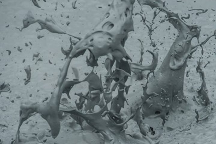
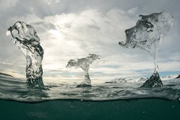
Vatnajökull & Jökulsárlón Glacier Lagoon
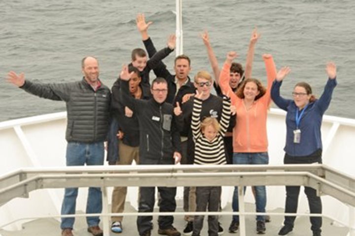
“BEEP, BEEP, BEEP” was the alarm call for those early risers who got up before expedition leader Lisa Kelley’s gentle wake up call, welcoming us to Djúpivogur, Iceland. Djúpivogur is located in eastern Iceland. We had lovely croissants for breakfast before taking a two-hour bus ride towards our day’s activities. We saw sheep, Icelandic horses, and noticed how the local geology caused all the mountains to slope towards the middle of the country. There was plenty of interpretation about these phenomenon by our Icelandic guides along the way. We arrived at the Jökulsárlón glacier lagoon in the morning and saw lots of ice- the same 800 year-old ice we were able to eat when we took amphibious vehicles into the water. The vehicles were used during the Vietnam War by the U.S. troops. It was a boat and a car all in one and we basically drove into the lake and floated atop the 160 meter deep lagoon below us. They were painted yellow and had huge wheels. As we were cruising around we saw ice of all shapes. Some looked like stairs turned upside down. Some had a very deep blue color but actually they looked this way because of the way the light of the rainbow passes through them. It was an awesome ride! Our morning at the lagoon was followed by lunch. Some chose to eat while others discovered the Wi-Fi connection and took advantage with some authentically Icelandic cyber activity. It was a ½ hour drive up to one of Vatnajökull’s exit glaciers following lunch. To get up to the ice we had to take 4-wheel drive vehicles. As we were approaching we could see a lot of waterfalls and the exit glaciers of the Vatnajökull ice cap. It was a narrow road with a steep drop with no guardrails. “It was weird,” said one of our young explorers , Theo, “for the first time I felt like my life was in the hands of someone I didn’t even know. When another car came it was even scarier!” Despite the excitement some managed to sleep through the scary drive. After arriving safely everyone who was snowmobiling had to put on “zoot suits” which made us all look “puffy as penguins.” We all had to listen to a safety talk so no one got hurt then we hit the surface of the glacier, some going faster than others. The feeling of the breeze flowing through our hair with the fresh wind of Iceland was refreshing and elegant! As wonderful as it may have been there was still energy for a snowball fight atop the exit glacier to Vatnajökull before our return. Many of us fell asleep on the ride home following a great experience filled with memories that will last a very long time!
6/30/2014
Read
National Geographic Explorer
Lilliehöökbreen, Stefan’s Garden, Krossfjorden
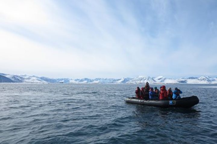
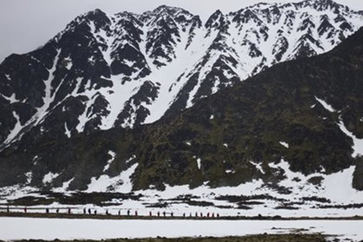
Our first full day in the Arctic is complete- not that yesterday really ended if you come from the perspective of the lower latitudes where the sun actually sets! I’m not sure about you but my day began at 3 a.m. with vibrant rays of sunlight bending towards my face through a double-paned porthole. Set in motion at that hour by the sun hanging a healthy 20 degrees in the sky, I ventured out on deck to be greeted by a great swath of Spitzbergen’s western coastline a few miles ahead. Outlined with jagged peaks belying its Norwegian name (spiky mountains) the atmosphere seemed to suggest calm, stable weather for our first day ashore. A slow approach to this western stretch of the Svalbard Archipelago bought us time to cover the logistics of an expedition to the high arctic: polar bear safety, Zodiac operations, the nuances of kayaking in cold waters, etc. As our informational morning progressed so did we, in the direction of a large fjord known as Krossfjorden. Just before the lunch hour we reached its northern reaches, coming face to face with an imposing ice barrier that feeds Krossfjorden a healthy supply of ice throughout the year. Lilliehöökbreen is a large tidewater glacier that is fed by catchment basins in the high mountains surrounding the northern end of the fjord. Pouring down in all directions like an amphitheater of ice our captain positioned us right along its frozen edge for a display of natural power not easily matched. Breaking off along a weak point in the ice wall a 70 foot tall, apartment sized piece of ice was born into its new role as “iceberg” before our very eyes. This adjustment triggered a domino effect of glacial collapse that left us rocking in its wake. Heading back south through Krossfjorden after lunch we anchored near a location known as Stefan’s Garden. Aptly named this west facing length of beach is well influenced by the North Atlantic Drift bringing warmer water from the Gulf Stream to these shores and helping a diverse community of wildflowers thrive in an otherwise inhospitable climate. Between perfect kayaking conditions and the opportunity to get ashore for the first time in the remote regions of Svalbard, our afternoon was picture perfect. Hikers took to the moss laden tundra while yellow kayaks dotted the calm, icy waters around our ship. Atlantic puffins, thick-billed murres, common murres, barnacle geese, and eider ducks all made a healthy appearance on the water while tufted saxifrage, moss campion, and Svalbard poppy graced the paths taken by the shore party. With nothing more than a light drizzle to contend with, a silvery, sun-patched sky quickly returned and ushered us into the closing hours of the day-a day not defined by sunrise and sunset but by boughs of beauty followed by a few hours of sleep.
7/2/2014
Read
National Geographic Explorer
Pack Ice and Woodfjord
After a night cruising in the ice, we pushed forward with the ship into the heavy pack ice. Cruising in pack ice with an ice-enforced ship is an amazing experience. Since National Geographic Explorer is not an icebreaker, there is a limit to how much ice we can plow through. However, with our skilled captain, we were able to use the leads that sometimes open, and this gave us an opportunity to push forward deep into the pack ice. Today we travelled along Reinsdyrflya (Reindeer Flat), and as we travelled in leads, we discovered some walrus hauled out on the ice. Two walrus illustrated how they use their tusks to haul themselves out of the water. It is good to see that the walrus numbers are increasing since they were protected in 1952 in Svalbard, and the population now is over 2000 animals, proving this to be a healthy population. At the entrance of Woodfjord, we spotted another polar bear. It was a very skinny bear, not a “happy fat bear” as we call them when they are in good condition. The bear was walking along the shore, and it suddenly started sneaking up on some reindeer, but did not succeed in the final approach. Normally we don’t expect to see polar bears stalking reindeer, but with the lack of other prey nearby this bear chose to use energy on a hunting attempt that is normally not successful. The reindeer is faster over a longer distance, and can outrun a polar bear. With luck, it might be possible to kill a reindeer, and this has been recorded, but the polar bear is a marine mammal and lives most of the year feeding on seals on the frozen sea. As we were dropping anchor and getting ready to start our afternoon Zodiac cruise we spotted a polar bear on one of the Andøyane (Duck) islands. The bear was raiding eider nests, which is not uncommon as sea ice diminishes, forcing bears to find food in other places. Since the polar bear was on land, we chose not to stress it more, so we did Zodiac cruises around the neighboring islands. We found some walrus hauled out on sea ice, and some in the sea swimming around the Zodiacs. Together with bearded seal and birds (king eider) this was a great Zodiac cruise. This great day ended with the ship cruising out from this beautiful fjord with a spectacular view of the surrounding mountains.
7/4/2014
Read
National Geographic Explorer
Greenland Sea
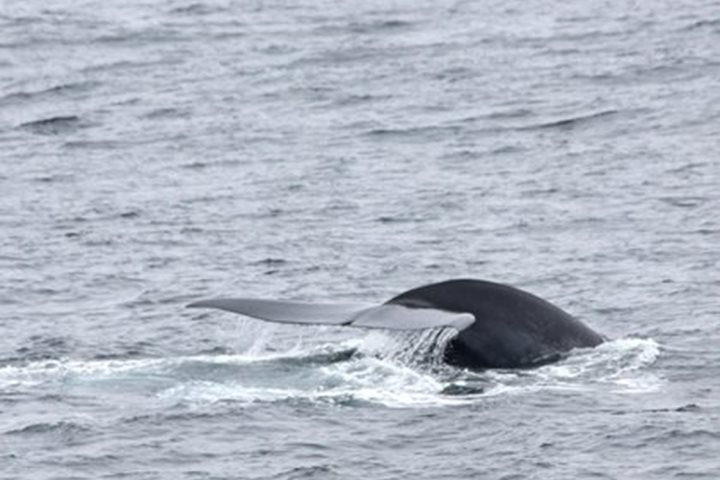
After several exciting days in the Svalbard Archipelago we now head towards Greenland on this, our first sea day on a magnificent Arctic voyage. To put our recent adventures into perspective, our young nine-year-old explorer reporter, Charlotte Fisher, shares her own reflections and those of other guests she has interviewed today. A relaxing day at sea was pleasantly interrupted after lunch by the appearance of a great blue whale in the middle of nowhere in the Arctic seas. This enormous animal proved to be one of the small minority of blue whales that lift their tail up when sounding and we were treated to several surface intervals and fluke-up dives by the feeding giant in gentle seas. Here’s Charlotte’s journal: Sunday My mother, grandmother and I just arrived at the National Geographic Explorer ship. We will be going through Svalbard and Greenland for fourteen nights. I am so excited!! We flew to a tiny town, the northernmost settlement in the world called Longyearbyen, and climbed up the stairs to the ship and unpacked. I looked out the window and I knew that it would be a good trip. They call this place the land of the midnight sun for a reason. It is ten o’clock at night and it looks like noon. It is pretty amazing!! We saw a blue whale tonight and it was huge! The whale is actually the biggest animal on the planet so that makes everything awesome. You can tell that the people really care about nature here. Can’t wait for tomorrow. Monday Today we got to go kayaking!! I saw puffins in huge groups sitting close up on rocks, along with black guillemots. There were also many beautiful flowers. The island was covered in grass because bird poop (ew!) is a great fertilizer. I am having a lot of fun and I am glad I came on this trip. Tuesday Today we saw our first polar bear!! Its blond fur helped him blend in with the snow. The polar bear was large and muscular. There was a bearded seal lying on the ice that the polar bear almost ate, but the seal rolled into the water at the last minute. It was amazing!! Wednesday Today my mom woke me up early because there were walruses on the ice. Soon after we saw a polar bear, and after that we saw another one that was skinny and therefore hungry and dangerous. It was also covered in dirt so it blended in with the ground. We also got to hear talks about polar bears and sea ice. They were both good but made me worry about global warming. The walruses (Odobenus rosmarus) were amazing!! They were huge, in fact, the largest pinniped in the Arctic. Thursday Today I interviewed some people on the ship and asked them, “What have you enjoyed most on this trip?” Here is what they said: “Blubbertown (Smeerenburg) and the Polar Plunge”; “Seeing a polar bear go after a seal”; “Seeing the walruses”; “The amazing calving”; “Walking in the snow brought back fond memories”; “It was so exciting to see red phalaropes in the pond in Ny Ålesund.” We celebrated the Fourth of July on board today with a visit from a blue whale and time to reflect on our experiences in Svalbard the past days. Onward to Greenland!
7/14/2013
Read
National Geographic Explorer
Sigufjordur and Akureyri, Northern Iceland
Our streak of good weather continues, as sunshine and calm winds greet National Geographic Explorer as we navigate the fjords of northern Iceland. Today we explore Iceland’s rich culture, past and present, in two of Iceland’s northernmost towns. After breakfast we go ashore at Sigufjordur, a small town with less than 2000 inhabitants, set against steep mountain slopes prone to dangerous avalanches that often block the road entering town during the long, dark Arctic winter. We are here to visit the award-winning maritime museum with its excellent displays, historic boats, and artifacts housed in refurbished warehouses. We are treated to a theatrical performance that recounts the colorful, and very profitable, history of herring fishing in the area. The black-headed gulls and Arctic terns also enjoy the demonstration, swarming and fighting over scraps of fish. During lunch and the early afternoon the ship repositions to Akureyri, the second largest town in all of Iceland, after Reykjavik, with almost 17,000 inhabitants, and the jumping off point for visiting the active volcanic and geothermal areas to the east. We are met by local guides for walks through downtown and up to the church for a panoramic view of the waterfront, before ending at the botanical garden. To the delight of the photographers, the garden is in full bloom during the height of summer. We enjoy the friendly atmosphere of downtown before returning to the ship for another delicious dinner. In preparation for tomorrow’s adventure to Lake Myvatyn, we enjoy a quiet night alongside the dock as the midnight sun paints the flat-topped mountains of Iceland’s longest fjord.
7/16/2013
Watch
National Geographic Explorer
Langanes Peninsula
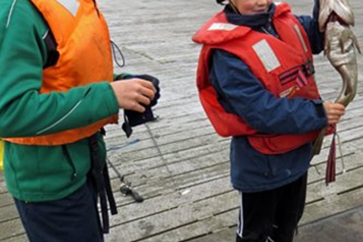
Here in the far reaches of Northeast Iceland sunrise came at 0252 hours to begin this long northern summer day. At 7 a.m., National Geographic Explorer is cruising in fog along the northwest coast of the Langanes—the “long peninsula” that is perhaps the most remote region of Iceland. Over the low swell and whitecaps of grey Greenland Sea, common guillemots fly low and straight while the ubiquitous northern fulmars wheel in soaring flight, skimming the waves. The wind and the swell made a Zodiac landing too treacherous to attempt on this shore, infamous for its history of shipwrecks. So we sailed southwest and found safe harbor at the small fishing village of Thόrshöfn—literally Thor’s Harbor. Here the harbormaster invited Captain Skog to bring our ship into his harbor. This is the first time such a ship has come here and we received a very warm welcome. A morning presentation on Rocks in Motion: The Tectonic Setting of Iceland by geologist and naturalist Jim Kelley explained the unique and dynamic geology of Iceland. This was followed by National Geographic photographer Chris Rainier presenting a fascinating account of Cultures on the Edge: Photographing on the Front Lines of the World in the 21 st Century. From the harbor we walked out across the dock and waterfront where local boys were fishing and work at a fish processing plant was in full swing, with great bins of fish fillets ready to freeze and export. On through the town we walked as the citizens greeted us warmly, surprised to find us in their small community. We proceeded out onto the tundra and passed farms where friendly and curious Icelandic horses also greeted us. On the way to a lake where common eiders and other ducks were swimming with their fast-growing ducklings, we saw many birds such as the golden plover, redshank, redwing, ringed plover, dunlin, and meadow pipit. A thrilling sight was a pair of great whooper swans flying overhead. We walked over the spongy tundra, stopping often to investigate myriad small and beautiful flowers and plants that grow in this special environment. After this full day of learning and exploring and reveling in the beauty of this far northern landscape, we enjoyed the presentation Of Elves and Trolls by Ragnar Hauksson.
7/18/2013
Read
National Geographic Explorer
Heimaey, Vestmannayer, Iceland
Today is our final day at sea during this circumnavigation of Iceland and we definitely saved some of the best for last. In the morning we sailed into the magnificent natural harbor of the island of Heimaey, the finest harbor in southern Iceland. Heimaey is home to about 4000 souls, most involved in the fishing industry in some way. In 1973 the peaceful life of the island was interrupted in the middle of the night on 23 January when a huge volcanic fissure running down the east side of the island opened up and began spewing hot tephra, ash, and lava onto the nearby houses. The eruption went on for months and immediately after it began the 5,200 people on the island were evacuated to the mainland. The lava added a large area to the eastern side of the island but it also threatened to close the harbor. The width of the entrance narrowed from 800 to 100 meters and the local workers with the help of the US Army Corps of Engineers sprayed seawater on the encroaching lava. Eventually the lava stopped and ironically left the harbor even better protected that it had been before the eruption. Unfortunately, however, about one third of the town was destroyed and the rebuilding took years. Today Heimaey is a very modern and prosperous Icelandic town as evidenced by their newest fishing trawler, called Heimaey, which happened to be tied up right behind National Geographic Explorer. After leaving Heimaey, we sailed southwest to visit the new island of Surtsey, which emerged in another fiery volcanic eruption in 1963. The island building event continued for four years and today the island is kept as a nature reserve and is being studied to find out how it will be colonized. Even though it was rainy by the time we arrived and visibility as reduced, it was still possible to see quite a lot of green on the hillsides, indicating that plants had already successfully colonize the lava. It was a wonderful end to a remarkable voyage around this most interesting of islands, the country of Iceland.
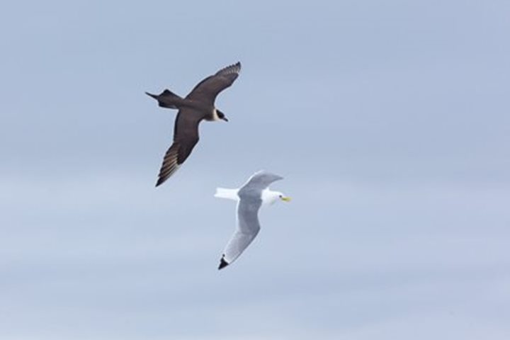
7/1/2014
Read
National Geographic Explorer
Smeerenburg & the Pack Ice
We were awoken early this morning, no rest for the wicked! The National Geographic Explorer was heading through the narrow passage of Sorgattet, between the island of Danskoya and Spitsbergen, and then into Smeerenburgfjorden. The passage was narrow, but the wildlife was good, with puffins, thick-billed murres, Arctic terns, and even several walrus being spotted before breakfast. As the butter melted on our toast, we anchored just off the island of Amsterdamoya and the once busy settlement of Smeerenberg, literally translated as ‘Blubber town.’ After breakfast we went ashore to explore, with hikes of various lengths being led around the shoreline, observing and documenting the historical remains of the old whaling settlement. We could clearly see the remains of the try-works, where large blubber rendering pots had been fired to reduce the whales hunted in this area to their commercially prized whale oil. There were other fragments of wood, metal and even grave sites discovered, all dating back to the hey-day of whaling here at the site in the early to mid-17 th century. But it wasn’t all about the history. There was a lot of wildlife to see as well, with shorebirds along the tidal zone, amphipods in the shallows, and Arctic terns flying around doing courtship displays and dipping into the water to catch said amphipods. Some groups also had a close encounter with a parasitic jaeger in a close-call dog-fight with a black-legged kittiwake. The dog-fight continued even after the kittiwake had sprayed the ground in front of one group with semi-digested amphipods as it tried to regurgitate enough food to stop the jaeger from harassing it. Phenomenal! We then headed back to the ship for lunch and cruised northwards towards the edge of the pack ice and 80 degrees north. The afternoon was spent approaching this area, and gently bumping through the sea ice was a new adventure for most. We were on the lookout for wildlife, and of course everyone was especially keen to see polar bears. There were plenty of seals around, which was definitely a good sign, with both ringed and bearded seals in abundance, and we had several excellent views of bearded seals as the captain brought the ship slowly in for close encounters. However, despite lots of keen eyes on the lookout, there was no sign of a bear…until dinner of course! One of our able-bodied seaman found our first bear during dinner, and as we finished our desserts we were all called to the bridge and outer decks to get our first views of this magnificent animal. We approached cautiously and slowly, and were able to see it swimming from one piece of sea ice to the next, almost bumping into a seal on the way, and then haul out and cross the ice in front of us. It slowly headed towards a bearded seal on the ice, and as it ran the last 60 meters towards the seal we waited with baited breath - but alas the seal was too alert and quickly dipped into the water. The captain relocated the ship and we had another close view of it, before it swam to another large floe where it attempted to catch another two bearded seals, missing both of these! Wow, what an exciting evening. But it wasn’t over. As we left the area and scanned more of the ice edge the scenery, skies, and sea were spectacular, with many of us enjoying time on the outer decks, well into the night…in the land of the midnight sun.
7/3/2014
Read
National Geographic Explorer
Hamburgbukta and Ny Alesund
This morning the mother ship dropped the hook off Hamburgbukta along the northwest coast of Spitsbergen Island. A very small bay, barely visible from the sea, was entered via a narrow entrance to a natural harbor surrounded by a dramatic glaciated landscape. Setting off on our excursions of the morning we were impressed by the lush tundra and abundance of lichens as we made our way across the rolling rocky terrain of Albert I Land (named after Prince Albert of Monaco who contributed significant baseline information that is used today to compare climate and glaciers of a century ago). Not far from the landing we encountered the remnants of a hut once used by Norwegian trappers and the walrus bones nearby helped to paint the picture of an exploitive past. Further along the coast, grave sites of whalers were found and coffins buried in the active layer of frozen ground were surrounded by scurvy grass in bloom. Death by this vitamin C deficiency was the curse of early sailors and the irony of the plant that helped save the lives of many growing on the graves was truly cause for pause. In the distance Little Auks swarmed like bees off the cliffs and the long walkers made approach to the scree slopes of which they nest upon. After lunch Captain Oliver steered us into the beautiful Blomstrandhamna area in Kongsfjorden where polar plungers braved the Arctic waters. Being surrounded by glaciers from Isachsenfonna (the Isachensen ice field) enhanced the experience and cooled the waters for the brave, bold and slightly cold! After dinner we made a special visit to Ny Alesund, one of the world’s northernmost year-round communities. Once a coal-mining town now dedicated to scientific research, this little slice of humanity in an archipelago largely devoid of inhabitants is one of the most significant historical sites in Svalbard. This site has been the starting point of several historical attempts to reach the North Pole by names like Amundsen, Ellsworth and Nobile. In the middle of town we found a statue of Roald Amundsen and further up the road could see the mast to which he attached his airship “Norge” in 1926 before launching on his transpolar flight over the North Pole and the Arctic Ocean. This attempt was preceded by an unsuccessful attempt by Amundsen to fly to the pole the year before in two German Dornier Wal flying boats. In 1928 the airship “Italia” launched from this site with Nobile as pilot but the flight crashed, prompting the first international air-sea rescue, during which Amundsen’s rescue plane went down and he was killed. Walking around the area we had close encounters with reindeer, arctic terns, and sled dogs and saw some amazing aerial predation by skua and glaucous gulls. Leaving the dock of Ny Alesund we bid farewell to the Svalbard Archipelago and started making our crossing across the North Atlantic to Greenland.
7/5/2014
Read
National Geographic Explorer
Cruising at Sea
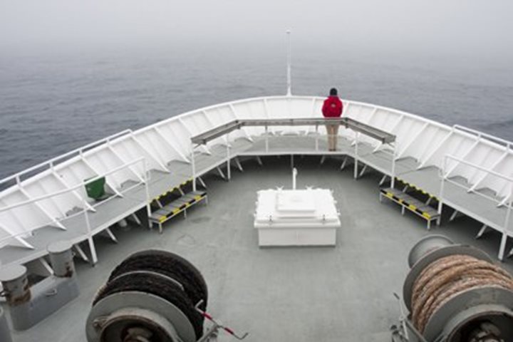
Today brought another day at sea, cruising a ways off the polar ice edge. The reason we’re not spending time right near the ice is that fog has enveloped the area, and visibility is extremely poor. So for safety reasons it is prudent to give the ice some room! Hopefully, visibility will increase at some point today, and we might have a chance to look for wildlife along our path near Greenland. This particular area can be subject to fog, because the colder Arctic waters and ice collide with the warmer Gulf Stream sweeping its way north toward Europe. Anytime you have these different temperature waters meeting, it is highly likely that fog can be a possibility! We’ll just have to wait and see what the rest of the day brings. It was still nice to get outside and experience the “open ocean!” Even though there was poor visibility for most of the day, we filled our time listening to several different talks, one on public speaking, another on pinnipeds, and finally a lecture on sea level change. There was also some time for another short photo “breakout session” just before tea time. Soon it was time for our evening recap and briefing. We heard about what we hoped to do tomorrow morning, a landing on a remote Island called Jan Mayen. Wish us lots of luck, and stay tuned! Another great dinner, and it was off to bed for some sleep, and dreaming about what would come tomorrow.
Showing 12 of 622